
Mapping the Past from Above: My Experience as Drone Lead at the Streethouse Dig


By: Ben Woodward, MSc Candidate
It isn’t every day that you’re asked to transport a twenty-pound flying machine a quarter of the way across the world — but, late last year, that’s what I was asked to do
This past July, I had the privilege of assisting with the Streethouse dig as the DRAGEN Lab’s drone lead. Over the course of three weeks, I learned how to transport and manage the Lab’s complex drone system, got my hands dirty coring for pollen and helping with the archaeological dig, and got to share an amazing three weeks with the Streethouse team.
Why use Drones for Archaeology?
Drones, or remotely piloted aircraft systems, are used for a wide range of applications, ranging from search and rescue to building inspection to precision agriculture. In my master’s research, I use drones to monitor shoreline change along Lake Huron.
In archaeology, drones have two main purposes. First, they allow researchers to efficiently map existing dig sites. Second, when combined with geophysical techniques, they can help identify new sites that may be archaeologically significant.
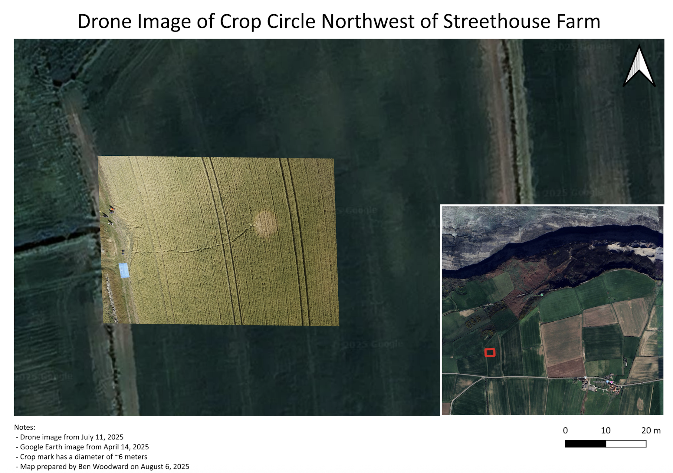
Drone image by Ben Woodward, Streethouse 2025.
Choosing the Right Sensor
Drones can be equipped with a variety of sensors, ranging from standard cameras to multispectral and thermal systems. The DRAGEN Lab’s drone carries a LiDAR sensor, which sends out millions of light pulses and records how long they take to return. Using this information, the sensor generates detailed 3D models of the landscape, revealing subtle changes in topography that may indicate archaeologically significant features.
A common misconception is that LiDAR can “see” underground. It can’t directly detect buried structures like stone circles or roads. However, under the right conditions, LiDAR data can still provide clues about what might lie beneath the surface.
A Unique Opportunity and a Mystery
This summer was unusually dry in Yorkshire. While the lack of moisture made excavation difficult and stunted crop growth, it also enhanced crop marks, making potential sites easier to spot.
Crop marks occur when buried features affect plant growth. For example, stone or concrete close to the surface can stunt crops, causing them to ripen early. Conversely, areas with more moisture —such as valleys — produce taller crops that ripen later. In this way, crops act as natural indicators of what lies beneath, giving archaeologists clues about hidden sites.

Diagram showing crop marks as they relate to different subsurface features.
From Wikimedia Commons.
During our survey, a local farmer brought our attention to a circular crop mark in one of his fields just west of the dig site. We did a survey of the crop mark, which supported our suspicion that it was caused by a concrete base from a communications tower used during World War II.
Getting my Hands Dirty
Although the dry weather offered many good flying days, I couldn’t fly the drone when winds were high or rain threatened. On those days, I jumped at the chance to learn a few other skills that were on my bucket list, including sediment coring and geophysical surveys.
I also spent several days working directly on the excavation. On my first day of digging I was lucky enough to find some rock art, and I later helped excavate an area that showed evidence of burning.
A Trip to Remember
All told, my time at Streethouse was incredible. In only three weeks, I gained hands-on experience with archaeology and paleoenvironmental analysis and levelled up my drone operations expertise. I am grateful to Steven Bednarski and the DRAGEN Lab for the opportunity, to Steve Sherlock for his hospitality and mentorship, and to all the DRAGEN Lab members who made the trip so memorable.